The Parcel Filter helps you to narrow down vast areas by using selectable criteria to find suitable parcels for development. With Parcel Filter, you can refine your search by applying filters for the following options:
Once you're done filtering, you can save your search to easily locate the project location again.
Getting Started
Navigate to the Map from the top of any page. The "Parcel Filters" toolbar will automatically populate, where you can refine your parcel search with the following options:

 Boundary: the area that's being reviewed for suitable parcels.
 Proximity: the proximity to transmission lines and/or substations.
 Size: the minimum or maximum acres of the parcels in your search.
  Owner: the parcels that have the same owner within your search area.
 Buildable Area: the total of buildable acreage for parcels within your search area.
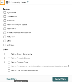
 Other: the parcels that are located in certain zoning, or within energy communities, protected areas, cleanup sites, tribal lands, and low income communities.
Filtering by Boundary
Within the toolbar, select Boundary. Here you'll have the option to filter parcels by:
-

 : Uploading a KML.
  : Dropping a point on the Map.
 /
/ : Drawing a polygon or a line.
  : Selecting certain features in the Map.
  : Defining a maximum distance from Distribution or Fiber Optic lines in your Map view (Please note that these are add-on features which may not be available to you).
After defining your boundary, you can set an optional radius to bring in criteria-eligible parcels within the surrounding area. Once you've defined your boundary, select Apply Filters.
You can also check out this tutorial for how to search along Distribution Lines.
Please note that you can only search search for distribution lines in the layers that have normal line geometries. We don't currently support: Commonwealth Edison (IL), DTE (MI), Portland General Power (OR), Public Service Co. of Colorado (CO), or San Diego Gas & Electric (CA).
Filtering by Proximity
Next, select Proximity to determine how close you want your project site to be to transmission lines and/or substations. You can input a distance (miles) and min/max voltages. You can also check the toggle to view the Transmission Line or Substation on the Map. When you're finished, select Apply Filters.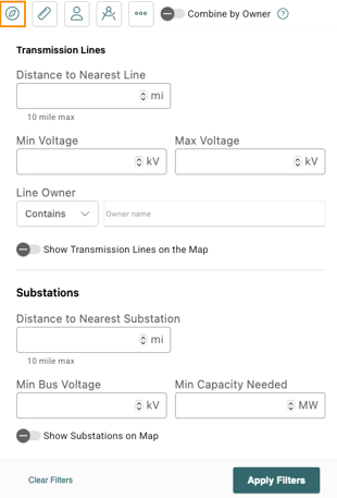
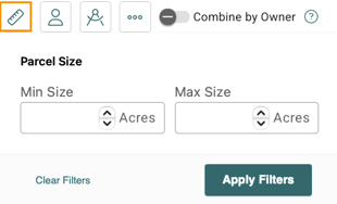
Filtering by Parcel Size
If you're looking for projects based on a specific amount of acreage, select Size from the toolbar, then input the min size and/or max size. When finished, select Apply Filters.
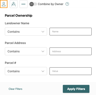
Filtering by Owner
If you're looking to find parcels with the same owner, you can filter by landowner name. You can also filter by parcel address or parcel number. When you're finished, click Apply Filters. You can also combine adjacent parcels with the same owner by toggling ![]() .
.
If you're looking to select multiple parcels with the same owner, you'll first want to clear your boundary (if applicable). Next, within the "Parcel Filter" toolbar, select Boundary and then Draw Polygon. You'll draw a polygon around all parcels with the same owner, then apply a 0 buffer. When you're finished, you can save it as a project or run a report.
Filtering by Buildable Area
If you're looking for parcels that have a specific percentage or amount of buildable acreage, you can filter by Buildable Area. First, select Set Buildable Area Criteria (e.g. wetlands, slopes, protected waterways, etc.) and select Save when finished. You can toggle to Show Buildable Area on the Map to visualize the buildable area. Additionally, input the minimum amount of acreage or the percentage of buildable area within a parcel to filter for parcels that meet the set criteria. When finished, select Apply Filters.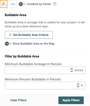
Additional Filtering Options
You can access additional filters by clicking More. From this page, you can look for parcels with a certain zoning code, or within energy communities, protected areas, cleanup sites, native sites, and low income communities. To apply filters, check the applicable boxes select Apply Filters.
Saving a Search
After finding the ideal project location, you can save it by selecting Save Search and adding a name. When finished, select Save. The pop-out on the right-side will highlight information about your site selection, including the concern breakout, key details, and parcel information. This information can be exported to CSV by selecting the Export icon.

Once you have found the right collection of parcels for your project, you can export them to a Project to share with others or create a Transect Report