Protected Areas are designated geographical spaces managed to preserve vital natural or cultural resources. Transect automatically identifies if your project site overlaps with or sits adjacent to these areas. Mapping these boundaries early is critical, as they often introduce development restrictions, specialized permitting requirements, or mandatory agency coordination. By delivering clear land ownership and regulatory data, Transect ensures you can accurately assess potential impacts on your project's footprint, timeline, and budget.
In this article, we’ll review:
- Protected Area Datasets
- How to View Protected Areas
- Protected Area Concern Levels
- How to Understand Land Ownership and Management
- How Transect Data Differs from Public Basemaps
Check out this article for more information on how protected area concern levels are calculated.
Protected Area Datasets in Transect
Protected Areas in Transect rely on two datasets:
- USGS Protected Areas Dataset (PAD-US)
- The USGS Protected Areas Dataset (PAD-US) is the official terrestrial and marine protected areas inventory for the United States. Transect uses this data to show users protected public lands that intersect with their project, including federal, state, regional, local, joint, and governmental organizational interests.
- U.S. Census Bureau's Current American Indian/Alaska Native/Native Hawaiian Areas National Dataset
- The dataset includes federally recognized reservations, off-reservation trust lands, state-recognized reservations, Hawaiian homelands, and various statistical areas for Alaska Native, Oklahoma, and tribal regions. It also covers joint-use areas claimed by multiple tribes. The boundaries for state-recognized reservations and certain statistical areas were determined by state officials for the 2010 Census.
Viewing Protected Areas in Transect
Protected Areas can be viewed in both the Map and within a Transect Report.
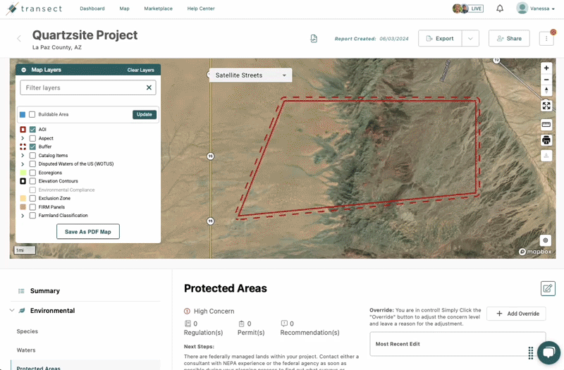
To view Protected Areas on the Map:

- From the Dashboard, select Map from the top navigation bar.
- Navigate to the Map Layer modal to search for Protected Areas. If you don't see these layers, click here to learn how to add the layers in the Map Layer Manager.
- Choose a Protected Area layer from one of the following:
- Protected Areas: This data comes from the PAD-US database.
- Protected Areas (No Known Mandate for Biodiversity): This data comes from the PAD-US database. This layer highlights areas where there are no known public or private institutional mandates, easements, or deed restrictions that prevent the conversion of the habitat to an unnatural land cover or the management intent is unknown.
- Protected Areas Risk Map (CONUS): This layer is a combination of datasets to visualize risk, but is only available for the 48 lower states.
- Current American Indian/Alaska Native/Native Hawaiian Areas National (AIANNH): This layer highlights the presence of tribal communities on the map.
- The selected layer will populate directly on the Map.
To view Protected Areas in a Report:
- Within a report’s Executive Summary, there will be a color-coded concern level for the Protected Areas. Click Learn More to navigate to the details page.
- Alternatively, select Environmental from the left-side menu and then select Protected Areas.
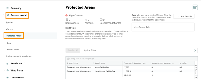
- Within the Protected Areas table, click a line item to be directed to that location on the Map:

Protected Area Concern Levels
- High
: The concern level will be high if there are federally owned or managed lands within the AOI.
- Moderate
: The concern level will be moderate if there are state or locally owned or managed lands and/or tribal lands within the AOI, but no federal lands.
- Low
: The concern level will be low if there are no protected areas or tribal lands in the AOI.
Understanding Land Ownership and Management
After running a Transect Report, a concern level for Protected Areas will be applied based on the aforementioned criteria. This data can be referenced by selecting Environmental > Protected Areas from the left-side menu. The Protected Areas data table will highlight the owner name, local name, manager, category, designation type, and more. You can also see how many acres are within the project boundary.

The “Category” column indicates the various kinds of public land interest in a property. You will see the following categories in this field:
- Fee: Land owned outright by public agencies, nonprofits, or private entities.
- Easement: Non-sensitive conservation and open space easements provided by the National Conservation Easement Database (NCED).
- Designation: Not an ownership boundary. Instead, these are policy-designated areas that may overlap fee-owned land, easements, or other designations.
- Marine Area: Protected waters, including federal, state, and local areas in the National Oceanic and Atmospheric Administration (NOAA) MPA inventory and areas managed by the Bureau of Ocean Energy Management (BOEM).
- Approved, Proclamation or Extent Boundary: Not an ownership boundary. These are administrative boundaries used for management or reference purposes. A land agency may want to secure more land or make overall plans in these areas. These boundaries frequently include significant private land, but no agency jurisdiction over them exists.
- Combined: Includes one or more of the above categories.
How Transect Data Differs from Public Basemaps
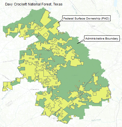
Many maps oversimplify public land ownership by showing national parks and forests as large, unbroken federal territories, but the reality is much more complex. These areas typically contain a mix of public and private lands within their administrative boundaries.
To provide accurate and reliable land ownership information, Transect utilizes the Protected Areas Dataset (PAD-US) rather than administrative boundaries. This ensures that users have a clear understanding of who actually owns the properties impacted by their projects.
The image below illustrates the difference between the administrative boundary and actual surface ownership within Davy Crockett National Forest.
Sources
- GreenInfo Network. What to Know Before Using PAD-US Version 2.0. Source Link
- U.S. Geological Survey (USGS) Gap Analysis Project (GAP). (2018). Protected Areas Database of the United States (PAD-US) Metadata. Source Link
- U.S. Census Bureau, Department of Commerce. (2019). TIGER/Line Shapefile: Current American Indian/Alaska Native/Native Hawaiian Areas (AIANNH) National. Source Link