When creating a Transect Report, you will have the option to add a buffer around your area of interest. This buffer will impact the findings and data found within your Report.
In this article, we’ll review:
- What is a Report Buffer?
- How do I add a Report Buffer?
- How does the Report Buffer impact concern levels?
- What should I set the Report Buffer to for my project?
What is a Report Buffer?
A buffer is a region surrounding an area of interest (AOI) that helps assess potential impacts. The buffer is important to consider when evaluating potential impacts because events or changes within the buffer area can sometimes affect the project itself and/or its permitting requirements. By including and assessing impacts to the buffer area, we can better identify and mitigate potential risks that might arise from unforeseen circumstances outside the main project area.
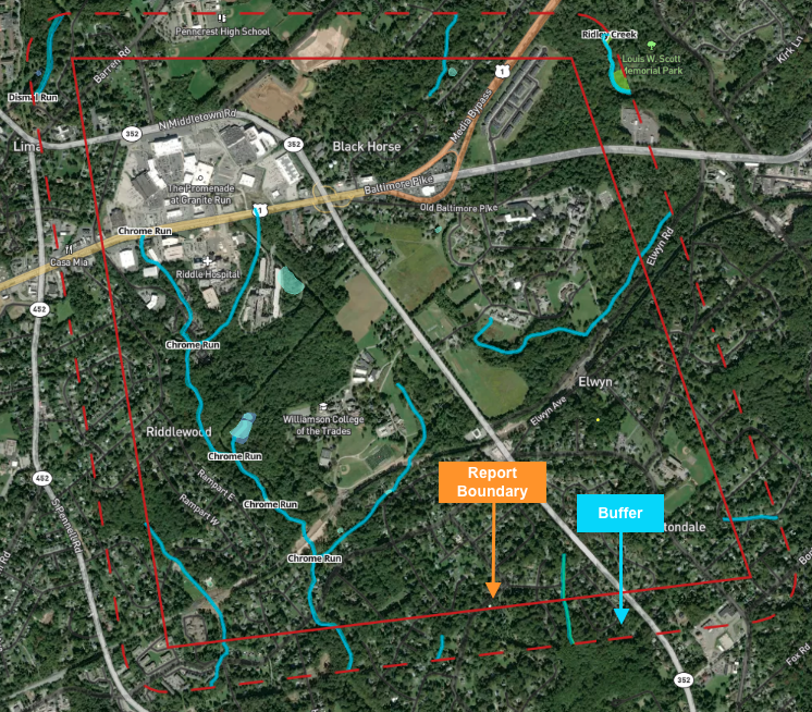
The report buffer is different from a conservation buffer, which is specifically designed to protect natural areas from being impacted during development. However, both can affect project development. For example, in Massachusetts, a 100-foot buffer is required around wetlands, influencing project planning and permitting.
How do I add a Report Buffer?
Report Buffers are added when creating your Transect Report by dragging the radio dial or adding a value in the context box for your preferred distance (in ft). Please note that the maximum buffer is 5280 ft (1 mile).
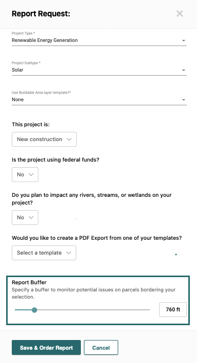
By default, the buffer will be set to 660 ft to comply with the USFWS recommendation for bald eagle nests.
Once you run a report, you can modify your buffer by navigating to Supporting Resources > Essentials. From this page, you'll input your preferred buffer and click Update Report Context.

How does the Report Buffer impact concern levels?
The Report Buffer impacts each of the concern levels in the following ways:
- Species Concern: The Species Concern Level will increase if a species is found within a buffer, as it could be due to migration, even if they don’t commonly nest there. For example, Transect will advise users if their project is located within the mitigation corridor of the whooping crane, even though it is unlikely to nest there.
- Waters and Wetlands: Waters and wetlands within the buffer don't affect water concerns, but there are situations where permitting requires an area outside of a wetland or waterway to also be protected. However, some states, like Vermont, require permits for projects within 250 feet of all lakes greater than 10 acres. In these cases, water concerns may rise, even if the lake isn't directly within the project area. The permit will appear if the AOI is within 250 feet of a lake, even if the lake does not directly intersect the AOI.
- Protected Areas: Protected area concern levels are not affected by the buffer. The concern level will only change if the project is within the protected area itself.
- Environmental Compliance: Environmental compliance concern levels are affected if environmental contamination is located within the buffer because contamination can potentially migrate from a place within the buffer to a place within the AOI. For example, a leaking underground storage tank on a neighboring property could pose a risk to the project.
What should I set the Report Buffer to for my project?
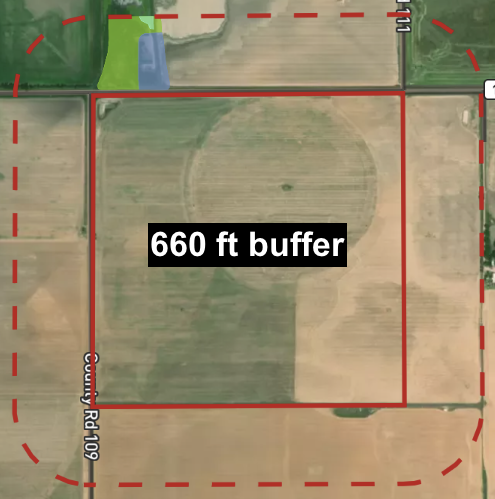
Buffer distances can vary based on project scope, location, and specific regulations. While our standard is 660 feet (or 1/8 mile), customers can adjust this to suit their needs. The 660 feet buffer is the average distance needed to consider impacts outside the AOI for a standard project.
Larger, more complex projects often require larger buffers due to increased permitting demands. Some states and municipalities have specific buffer requirements for certain development types, such as wind farms or large-scale renewables. Additionally, projects in sensitive areas might need extra buffers to mitigate environmental impacts.
Here are some examples:
- Indiana set standards for wind development projects that suggest a one-mile buffer from state parks or municipality boundaries for projects.
- New York requires larger buffer distances for large-scale renewable energy projects. Under Section 94-c, developers must conduct a qualitative assessment to determine the project's compatibility with existing and proposed land uses within a one-mile radius.
- Pennsylvania has a stream classification program and requires a 150-foot buffer on all High Quality or Exceptional Value watersheds for all earth disturbance projects greater than 1 acre.