Slope and aspect are critical factors influencing the success of renewable energy projects. By carefully analyzing these elements, renewable energy developers can optimize site selection and system design for maximum energy output while minimizing environmental impact. In Transect Reports, you can review and de-risk your project site using the Slope and Aspect baselayers.
In this article, we’ll review how to:
Please note that Transect’s slope data is derived from the USGS 3D Elevation Program. You may notice variations in slope granularity, which can be influenced by factors such as map scale, data resolution, terrain complexity, and the specific processing methods used by USGS.
Viewing Slope and Aspect
Slope and Aspect are available in both the Map and Reports. There are two layers in the Catalog:
- Slope Map: The maximum rate of change in elevation over a distance.
- Aspect Map: The direction that the plane faces with the corresponding steepness.
To view the layers in the Map, check the box next to the applicable layer in the Layer Modal.

You can follow the same steps to view slope and aspect in your report; however, only the data that is found within your project boundary will be shown.
Understanding the Legend
Within the Map Layers modal, you can learn more about these layers by selecting the down arrow to the right of the layer:

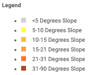
The Slope baselayer’s colormap is represented with the following colors:
- Light Grey: Very gentle slope, almost flat.
- Yellow: Gentle slope with slight undulations.
- Orange: Moderate slope with noticeable hills.
- Peach: Rolling hills with steeper sections.
- Orange-Red: Steep slopes with distinct hills or ridges.
- Brown: Very steep to mountainous terrain.
The Aspect baselayer’s colormap is represented with the following colors:
- Green: North-facing slopes receive minimal direct sunlight, which is less ideal for solar panel installations.
- Blue: East-facing slopes receive morning sunlight and afternoon shade.
- Purple/Pink: South-facing slopes receive maximum sunlight exposure throughout the day, making them the most desirable orientation for solar panel installations.
- Orange/Yellow: West-facing slopes receive afternoon sunlight and are shaded in the morning.

In Transect, Aspect visually represents both the direction (aspect) and steepness (slope degree) of a terrain or surface.

- Aspect is indicated by color hue (e.g., red, green, blue).
- Slope degree is represented by color saturation or brightness, with darker colors representing gentler slopes and brighter colors indicating steeper slopes.
Source: ESRI